European imaging companies step in to fill warzone gap
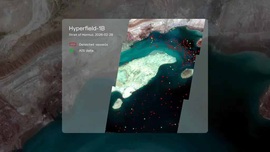
European Earth-observation companies are stepping in to provide satellite imagery as U.S. firms restrict access to visuals of Iran and the Gulf conflict. This shift has created new business opportunities for European firms, particularly in the energy sector, which relies heavily on such data. The situation has prompted increased interest from media organizations seeking reliable information about the Strait of Hormuz and its impact on global trade.
- ▪U.S. satellite imagery companies have pulled back from sharing visuals of Iran and the Gulf conflict.
- ▪European firms are filling the gap, receiving increased requests from energy traders, insurers, and media organizations.
- ▪The European Union's Copernicus program continues to operate without restrictions, providing a potential solution.
Hacker News (Newest) files mainly under programming. We currently carry 5,306 of its stories.
Story provenance
Source · retrieval · rights · ranking — open for full record
inspect →
Story provenance
Attribution is not the same as permission. This drawer separates discovery metadata, excerpts, WeSearch-generated summaries, reuse status, and whether the publisher receives the visit. Nothing here claims a legal grant the publisher has not made.
Record
| Original publisher | SpaceNews |
| Canonical URL | https://spacenews.com/european-imaging-companies-step-in-to-fill-warzone-gap/ |
| Publication time | Mon, 18 May 2026 21:49:13 +0000 |
| Retrieval time | 2026-05-18T22:04:56.986Z |
| Last seen | 2026-05-18T22:04:56.986Z |
| Headline source | Publisher (no WeSearch rewrite) |
| Excerpt source | publisher body |
| Excerpt method | First ~120 words (~800 chars) of extracted publisher body, fair-use limited. |
| Summary | WeSearch · cerebras-chat (WeSearch summarizer) |
| Summary source text | contentText |
| Citation coverage | Summary is a WeSearch-generated derivative; primary citation is the original publisher URL. |
| Cluster | 6KAVHfl10und |
| Cluster logic | Grouped by semantic title/content similarity across sources within a rolling window. Same-publisher template collisions are excluded from coverage comparison. |
| Ranking reason | Story pages are not engagement-ranked. Hub feeds use recency, with optional source-diversified chronological ordering (cap consecutive stories per source). No personalized ranking. |
| Publisher visit | Yes — open original |
| Substitutes article? | No — link-out required for full text |
Rights status (four layers)
WeSearch handling by dimension
| Indexing | May the item be indexed (stored, ranked, made findable)? | Allowed |
| Snippet | May a short excerpt of the publisher's text be shown? | Allowed |
| AI summary | May WeSearch generate its own short summary of the article? | Limited |
| Retrieval / RAG | May the content be exposed for third-party retrieval-augmented generation? | Not asserted |
| Model training | May the content be used to train AI models? | Not asserted |
| Commercial reuse | May the content be reused commercially? | Not permitted |
Basis: Derived from the published RSS/Atom feed. Contact: [email protected]. Reviewed: 2026-07-24.
Opening excerpt (first ~120 words) tap to expand
MILAN – As U.S. satellite imagery companies have pulled back from sharing visuals of Iran and the broader area around the Gulf conflict, European Earth-observation firms are moving to fill the vacuum. The new business is coming from global energy traders, insurers, shipping firms and news organizations, all of whom depend on commercial satellite imagery to monitor one of the world’s most sensitive waterways: the Strait of Hormuz. “In the energy sector, Earth observation data has become a core part of the business in the last five years,” Antoine Rostand, president and co-founder of French environmental intelligence company Kayrros, told SpaceNews. Sign up for First Up: Get the latest updates on SpaceX, Artemis, NASA and more.
…
Excerpt limited to ~120 words for fair-use compliance. The full article is at SpaceNews.
Discussion
0 commentsMore from SpaceNews